Aquarius ENC Plotter 2021.0
Free Version
Publisher Description
Aquarius ENC Plotter - Navigate using NOAA's official, freely available electronic charts.
Navigate using official, free electronic charts intended for navigational use. Download for free over 1400 Electronic Navigational Charts (ENCs) directly from NOAA, or supply your own S-57 compliant charts. ENCs from NOAA are intended for navigational use, and each downloaded chart is an official NOAA ENC®.
Aquarius provides fast and efficient plotting of ENCs, on your phone or tablet. Multiple charts are simultaneously displayed for a continuous panoramic effect at all zoom levels.
Features:
- Display current weather and sea conditions. Data from National Data Buoy Center (NDBC) buoy stations.
- Display tide predictions and water level measurements. Data from NOAA's tide and water level stations.
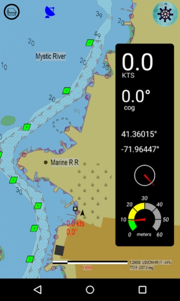
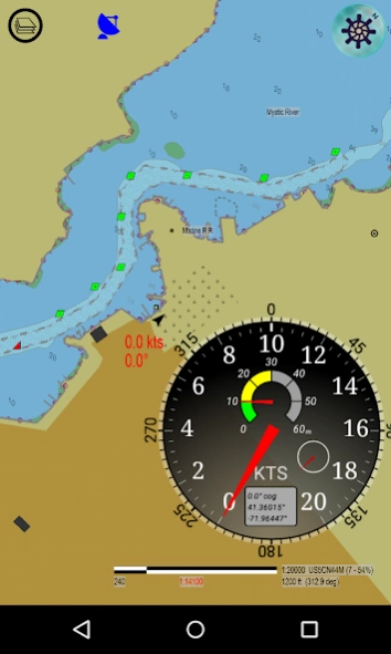
- GPS location is plotted with a choice of three different modes: Fixed map mode, and two moving-map modes (north or any orientation up, and course up). Bearing and speed over ground is displayed. Turn on or off to save battery.
- Reconfigurable, resizable, re-positionable combo-gage for GPS information display, in analog and digital styles.
- Facts-on-the-ground verification. Display ENCs as an overlay on Google maps. Select road, satellite, or hybrid map tiles. See the "real life" details underneath the symbols, such as the apparent condition of boating facilities and other features, as of the date of the imagery. Go to www.appliedvanilla.com to see video: Aquarius ENC Plotter with satellite maps
- Verifiable data integrity. Downloaded charts retain their original file names and contents, and can be browsed independently.
- Fast, direct ENC-to-Display processing. After every start-up, Aquarius directly reads only the true, official, original ENC (S-57) files on your device's storage that you put there. Aquarius does not read a proprietary format or derived database. Aquarius is not a front-end for web-based tiled ENC imagery. This feature increases the reliability of the entire supply chain by significantly shortening it. This is the single most important feature the competition does not want you to know about, because it renders the middleman's lucrative niche obsolete.
- Advanced object query. Objects are identified and highlighted individually. Calibrated background grid facilitates measurements. Toggle between single-pick and cruise mode. In cruise mode, just pan the screen, and information for objects falling under the crosshair is automatically displayed, with lag-free responsiveness. Page through overlapping or coincidental objects.
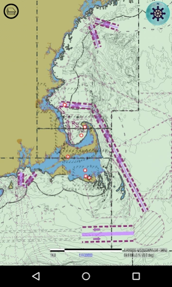
- Set Safety Contour depth, and choose 2 or 4 colors for depth area display scheme. This critical feature lets you customize the ENC display to your boat's draft, to avoid grounding. The lighter-shaded areas on the display are "safe" areas for your boat. Depth soundings are also displayed, but the lighter-shaded areas are the key.
- Isolated Dangers are automatically displayed, using your Safety Contour depth setting.
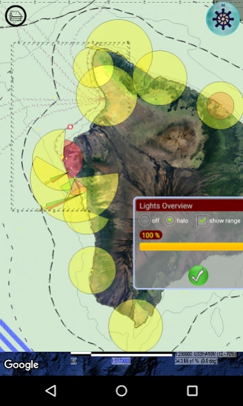
- Lights overview. A concise wide-area display of all lighted objects (Lighthouses, etc), with visibility/range halo.
- Richer and cleaner detail. Chain-link style symbology for paths and area boundaries. Symbols don’t get distorted at corners, and jagged paths are smoothly interpolated according to zoom level.
- ENC update files are processed, for the most up-to-date and accurate chart display.
- Reads Inland ENC (IENC) charts, such as those from the Army Corps of Engineers (see screenshot with photo of bridge).
- Graphical display of chart catalog, for downloading and display. Download charts individually or by custom-selected area.
- Display only the charts you select, or let Aquarius automatically display charts as you browse.
- Charts reside in your own designated folders. Individual folders can be turned on or off as layers.
- Content is substantially free; moving-map modes for GPS, combo-gage, and Google maps satellite and hybrid modes are bundled together as a single purchase option.
- Built-in user guide. See videos on developer website.
About Aquarius ENC Plotter
Aquarius ENC Plotter is a free app for Android published in the Geography list of apps, part of Education.
The company that develops Aquarius ENC Plotter is Applied Vanilla Studios. The latest version released by its developer is 2021.0.
To install Aquarius ENC Plotter on your Android device, just click the green Continue To App button above to start the installation process. The app is listed on our website since 2021-11-05 and was downloaded 61 times. We have already checked if the download link is safe, however for your own protection we recommend that you scan the downloaded app with your antivirus. Your antivirus may detect the Aquarius ENC Plotter as malware as malware if the download link to com.appliedvanilla.android.chart57app is broken.
How to install Aquarius ENC Plotter on your Android device:
- Click on the Continue To App button on our website. This will redirect you to Google Play.
- Once the Aquarius ENC Plotter is shown in the Google Play listing of your Android device, you can start its download and installation. Tap on the Install button located below the search bar and to the right of the app icon.
- A pop-up window with the permissions required by Aquarius ENC Plotter will be shown. Click on Accept to continue the process.
- Aquarius ENC Plotter will be downloaded onto your device, displaying a progress. Once the download completes, the installation will start and you'll get a notification after the installation is finished.
